Geospatial Foundation Models: The Land-Grab to Build the "GPT of Earth Observation
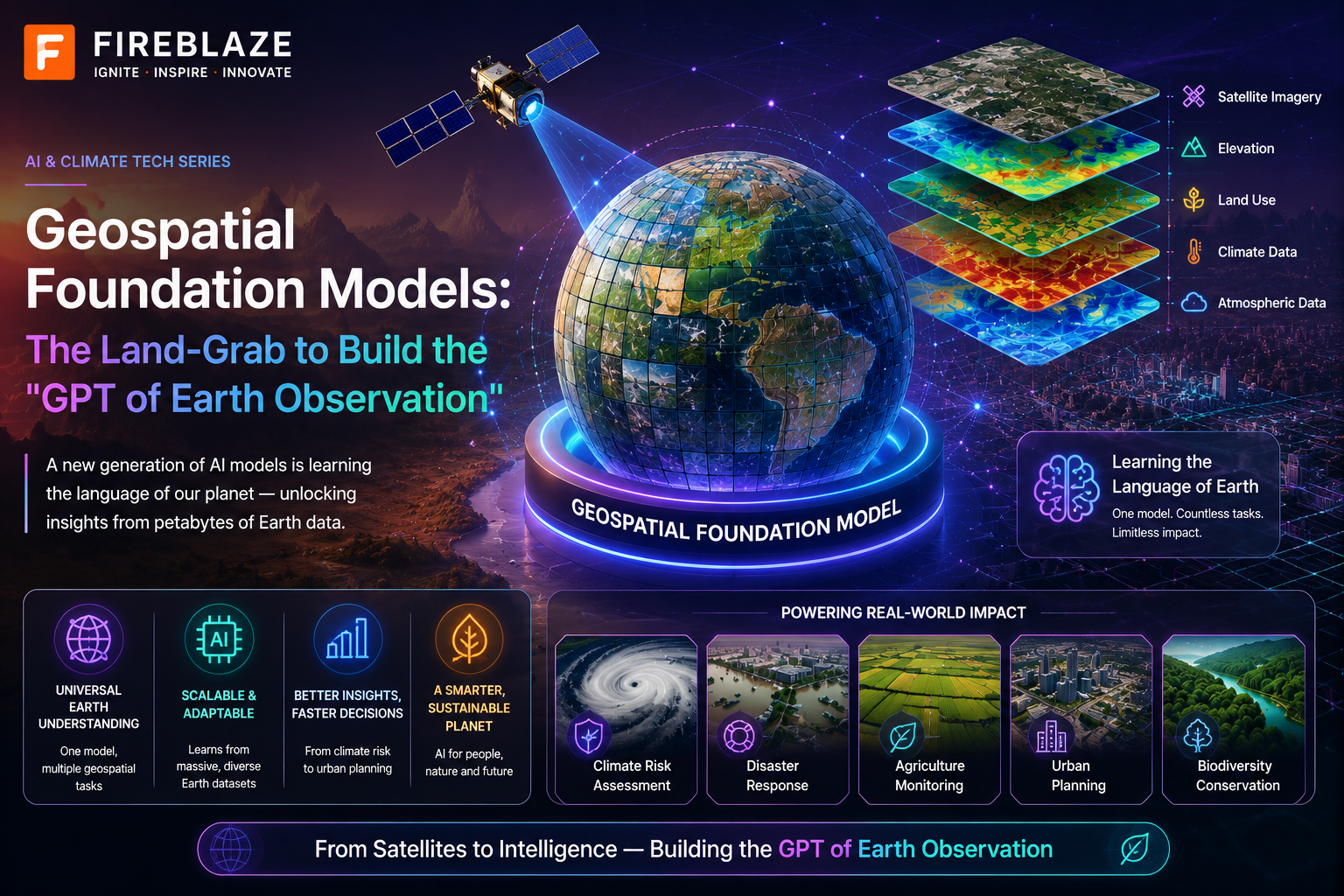
Geospatial Foundation Models: The Land-Grab to Build the "GPT of Earth Observation"
A market-trend piece on the newest and least-covered land-grab in applied AI: pretraining one large model on unlabeled satellite imagery via self-supervision, then fine-tuning small task-specific heads on top of it for flood mapping, wildfire scar detection, and crop classification — instead of training a separate bespoke model from scratch for every single one of those problems.
1. Hook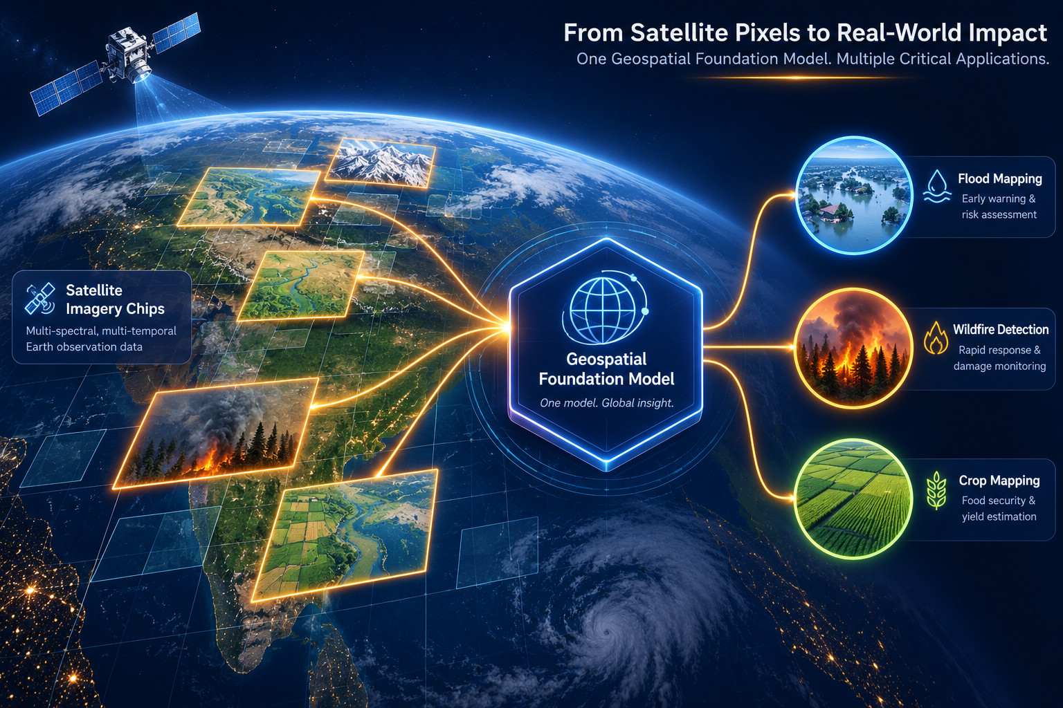
For most of remote sensing's history, "AI for satellite imagery" has meant one model per problem: a flood-detection model trained on flood-labeled imagery, a burn-scar model trained on burn-labeled imagery, a crop-classification model trained on crop-labeled imagery, each built from scratch, each starved for the labeled data that Earth observation notoriously lacks. That pattern is breaking, fast, and the shift has a name borrowed directly from the language-model world: the geospatial foundation model (GFM) — a single large model pretrained once, via self-supervision, on massive volumes of unlabeled satellite imagery, that can then be fine-tuned with comparatively small labeled datasets for dozens of different downstream tasks. The analogy to GPT is doing real work here, not just marketing: the same "pretrain once on unlabeled data, adapt cheaply many times" economics that made large language models a platform rather than a single-purpose tool is now the explicit strategy behind NASA and IBM's Prithvi-EO, Google DeepMind's AlphaEarth Foundations, and the open-source Clay model — and unlike most AI hype cycles, this one is already running in production, and as of 2026, running in actual orbit.
2. Core Explanation
2.1 The Core Idea: Self-Supervised Pretraining on Unlabeled Pixels
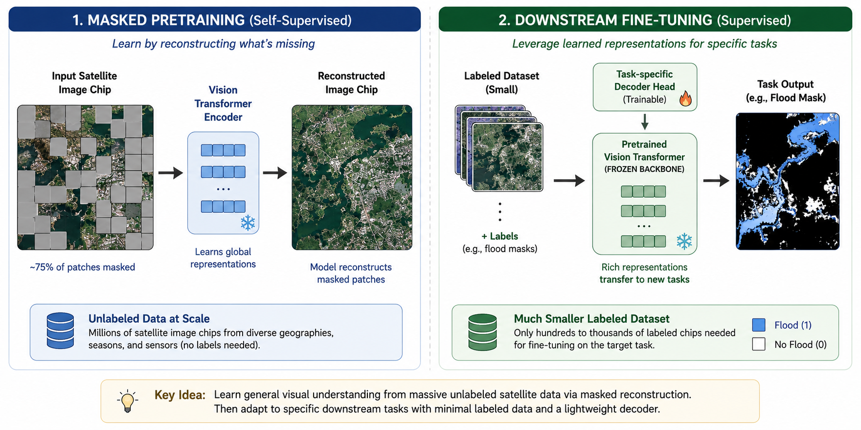
The mechanical trick underneath every GFM in this space is the same one that underlies most modern self-supervised vision learning: the masked autoencoder (MAE). During pretraining, large chunks of an input satellite image are hidden from the model, and the model — a Vision Transformer backbone — is trained to reconstruct the missing pixels from what remains visible. There's no human-provided label anywhere in this loop; the "ground truth" the model is learning to predict is just the original, unmasked pixels themselves, which means pretraining data is limited only by how much raw satellite imagery is available — effectively unlimited, since Earth-observation satellites have been continuously imaging the planet for over a decade. Prithvi's own technical framing makes the design intent explicit: it's a Temporal Vision Transformer that includes both positional and temporal embeddings, trained with a masked autoencoder approach — the "temporal" piece matters specifically because a satellite image isn't just a static photo, it's one frame in a time series, and a model that understands how a pixel's spectral signature evolves across a growing season or a flood event is learning something a single-frame model architecturally cannot.
Once this pretraining is done, the resulting model has learned a general-purpose, reusable representation of "what land surfaces look like and how they change" — and fine-tuning a lightweight decoder head on top of that frozen or lightly-adjusted backbone for a specific task (flood extent, burn scar, crop type) requires a small fraction of the labeled data and compute that training an equivalent model from scratch would need. This is precisely the value proposition driving adoption: reduce the labeled-data and training-cost bottleneck that has historically made remote-sensing AI expensive and slow to build.
2.2 The Field, Mapped: Who's Actually Building These
This is not a single-vendor story, and the differences between the leading models are architecturally real, not just branding. The clearest three-way split as of 2026 is between models you fine-tune yourself, models delivered as precomputed embeddings, and open community-built alternatives:
| Model | Developer(s) | Training Data | Architecture / Output | Deployment Pattern |
|---|---|---|---|---|
| Prithvi-EO (2.0) | NASA + IBM, with 42 contributors from 12 institutions | Over 7 years (dataset now spans up to 13 years in later releases) of NASA's Harmonized Landsat-Sentinel-2 (HLS) imagery, ~4.2 million training samples across 800+ ecoregions | Temporal Vision Transformer, masked autoencoder pretraining, 6-band multispectral input (RGB, NIR, SWIR 1, SWIR 2) | Open-source model weights on Hugging Face; practitioners fine-tune task-specific decoder heads themselves |
| AlphaEarth Foundations | Google DeepMind | Petabytes of fused multi-sensor data — optical and thermal from Sentinel-2/Landsat, Sentinel-1 SAR, 3D surface measurements, elevation, climate reanalysis, descriptive text | "Embedding field" model fusing multiple modalities into a single latent space | Delivered as precomputed annual 64-dimensional embeddings at 10m resolution via Google Earth Engine — no GPU inference step required, consumed by classical ML (random forests, gradient-boosted trees) |
| Clay | Open community project (Clay Foundation / Radiant Earth-adjacent effort) | Multi-sensor open satellite imagery, including NAIP embeddings among published releases | Open-source Vision Transformer foundation model, actively versioned (v1.5 in production use as of 2026) | Open-source weights, fine-tuned by practitioners similarly to Prithvi |
The AlphaEarth design choice is worth pausing on, because it's a genuinely different bet about where the value in a GFM sits: rather than shipping a model practitioners fine-tune, Google DeepMind ships the output of the model — a dense, low-dimensional embedding for every 10-meter pixel on Earth's land and coastal surface — precomputed and hosted natively in Google Earth Engine, which trades fine-tuning flexibility for eliminating the GPU-inference step entirely and making the technology usable by teams with no deep learning infrastructure of their own at all.
2.3 Downstream Fine-Tuning: What "Flood, Wildfire, Crop" Actually Looks Like in Practice
The downstream tasks named in this piece's title aren't hypothetical — they're the specific, named fine-tuned variants that shipped alongside Prithvi's initial open-source release: a base model, a flood-mapping model fine-tuned on the sen1floods11 flood-labeled dataset, a burn-scar identification model, and a multi-temporal crop-classification model, released together specifically to demonstrate the pretrain-once-adapt-many-times pattern in practice rather than as a research curiosity. The intended production use is explicit in how the model's developers describe it: transforming satellite data into high-resolution maps of floods, fires, and other geographic changes, aimed at revealing environmental developments and helping prevent potential disasters before they escalate.
AlphaEarth's precomputed embeddings have followed a similar downstream fan-out since their mid-2025 release, with community-reported use cases spanning ecosystem mapping, agricultural crop-type classification and yield estimation, carbon-stock prediction, wildfire risk mapping, biomass estimation, and even non-obvious applications like gridded population mapping and slum-density mapping evaluated across multiple global cities — evidence that once a general-purpose embedding exists, the fine-tuning "surface area" of problems it gets applied to expands well past the model developer's original use-case list.
2.4 The Market Is Already Pricing This In
It's worth grounding the "hot, underexplored" framing in actual market numbers rather than leaving it as a vibe. Three overlapping market categories all show the same growth direction, at different scales:
| Market Segment | 2025/2026 Size | Forecast | CAGR | Key Driver Noted |
|---|---|---|---|---|
| Earth Observation market (global) | $6.21B (2025) / $7.68B (2026, one estimate) | $12.92B by 2035 / $14.55B by 2034 | ~7.7–8.3% | Government EO programs (NASA, NOAA, NGA), commercial players (Maxar, Planet Labs), rising defense budgets |
| Geospatial Analytics AI market (global) | $38.33B (2025) | $126.58B by 2035 | 12.69% | AI/ML integration with geospatial data across defense, agriculture, urban planning, disaster management |
| Geospatial Intelligence (GEOINT) market | $37.13B (2025) | $62.88B by 2030 | 11.1% | Compression of decision timelines, geo foundation models and transfer learning explicitly named as an "opportunity" driver |
Two things stand out across all three estimates. First, every one of them explicitly names geo foundation models and transfer learning as an emerging growth driver rather than a settled, mature category — this is a market still being defined, not one being harvested. Second, the security & intelligence and defense & intelligence segments consistently show among the highest projected growth rates of any application vertical in the space (~15% CAGR for defense & intelligence specifically in one 2025–2030 estimate), which lines up directly with the kind of rapid-disaster-response and change-detection use cases GFMs are built to accelerate.
2.5 The Signal That Moves This From "Interesting" to "Infrastructure": Orbit Deployment
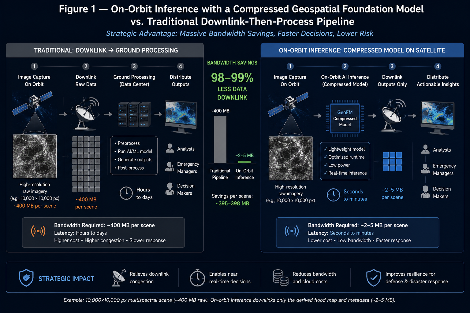
The single clearest data point that this technology has crossed from research demonstration into deployed infrastructure: in 2026, a team from Adelaide University, ESA's Φ-lab, Thales Alenia Space, and the SmartSat Cooperative Research Centre successfully uploaded and ran a compressed version of the open-source Prithvi model aboard two actual in-orbit platforms — South Australia's Kanyini satellite and the Thales Alenia Space IMAGIN-e payload mounted on the International Space Station — making it the first geospatial foundation model ever deployed in orbit, and testing its flood and cloud-detection performance directly on the spacecraft rather than on imagery downlinked to a ground station first. The strategic implication for anyone building on this technology is significant: running inference on the satellite itself, rather than downlinking raw imagery to Earth for processing, means faster disaster response and dramatically less bandwidth consumed transmitting data that a model could have filtered or summarized in orbit — the kind of edge-deployment advantage that only becomes possible once a single general-purpose model is small and capable enough to compress and fly, instead of needing a separate bespoke model designed and validated for each individual task running on the ground.
2.6 A Caveat Worth Taking Seriously: Foundation Models Are Not Interchangeable, and Not Universal
This is the section that keeps the "GPT of Earth Observation" framing from becoming an overclaim, because the analogy breaks in a specific, important way. Unlike large language models, which converged fairly quickly on transformer-decoder architectures trained on broadly similar internet-text corpora, constructing visual foundation models for remote sensing has run into a genuinely harder problem: formulating the enormous diversity of geospatial vision tasks into one general problem framework, which is precisely why the field still has multiple structurally different leading models (a fine-tunable open-weights model like Prithvi, a precomputed-embedding product like AlphaEarth, a community open-source alternative like Clay) rather than one dominant architecture the way GPT-style models have converged on for text.
Practically, this has two consequences worth naming directly. First, evaluation work directly comparing Prithvi against other pretrained, task-specific models has found that its advantages are genuinely dataset-dependent rather than universal — one detailed evaluation found input-resolution effects on performance varied by dataset characteristics (how sharp or blurry the object boundaries were in a given imagery type) rather than following one consistent rule, meaning "just fine-tune the foundation model" is not automatically the right call for every geospatial problem without checking. Second, and more bluntly, a detailed 2026 practitioner write-up on agricultural applications of Prithvi, Clay, and AlphaEarth is explicit that foundation models are not magic, and names specific categories of problems — sub-meter perception tasks like weed segmentation, fruit counting, and disease-lesion detection from in-cab or drone cameras — where these models' pretraining corpora simply don't provide meaningful help, because the pretraining imagery's native resolution doesn't cover that regime at all. The honest framing: GFMs meaningfully lower the cost of building a broad range of Earth-observation applications, but "broad range" is not "all of them," and which model fits which problem — fine-tunable backbone versus precomputed embedding, which spectral bands and resolution regime — is still a real engineering decision, not a solved default.
2.7 Common Pitfalls
- Assuming "foundation model" means one dominant, interchangeable product. As Section 2.2 and 2.6 lay out, Prithvi, AlphaEarth, and Clay differ architecturally and in deployment pattern (fine-tunable backbone vs. precomputed embedding vs. open community model) — picking one is a real technical decision, not a commodity choice.
- Treating benchmark wins on one downstream task as evidence the model is optimal for every task. Section 2.6's resolution-dependent, dataset-dependent evaluation findings are the clearest illustration of why a model that excels at flood mapping isn't automatically the right choice for, say, sub-meter crop-disease detection.
- Underestimating how much the embedding-vs-fine-tune choice affects the rest of the pipeline. AlphaEarth's precomputed-embedding pattern eliminates GPU inference but locks a team into whatever the embedding was designed to capture; a fine-tunable model like Prithvi or Clay costs more infrastructure but allows task-specific adaptation the embedding approach doesn't.
- Missing that market-sizing numbers cited for "geospatial AI" often blend several distinct segments (raw Earth observation data/hardware, geospatial analytics software broadly, and GEOINT specifically) — as Section 2.4's table shows, these produce meaningfully different-looking market sizes depending on which segment is being quoted, and conflating them overstates or understates the addressable opportunity depending on which framing is used.
3. Worked Example / Analogy
Picture the shift in remote-sensing AI as similar to what happened in software development when cloud platforms replaced everyone building and running their own data center. Before geospatial foundation models, a team that wanted to detect floods from satellite imagery had to do the AI equivalent of building a data center from scratch: collect and label a flood-specific dataset, design a model architecture suited to that specific problem, and train it end-to-end, all before writing a single line of the actual application logic — and then a completely different team solving wildfire detection had to repeat nearly the entire process from zero, gaining almost nothing from the flood team's work even though both problems start from the same kind of satellite imagery. A geospatial foundation model is the "cloud platform" equivalent: the expensive, general-purpose infrastructure — understanding what land surfaces look like, how they change over time, how different spectral bands relate to each other — gets built once, by a well-resourced team, and everyone downstream rents a small slice of it, attaching a lightweight, task-specific piece on top rather than re-building the foundation. The flood team and the wildfire team are now both "renting compute" from the same underlying Prithvi or AlphaEarth backbone instead of maintaining separate data centers, which is exactly why fine-tuning costs and labeled-data requirements have dropped so sharply for teams adopting this pattern — the expensive part already happened, upstream, once, for everyone.
4. Application to Defense & Aerospace
For a Defense & Aerospace AI Center of Excellence, geospatial foundation models are arguably the single highest-leverage trend covered across this entire blog series, because GEOINT and defense & intelligence are consistently identified as among the fastest-growing application segments in every market estimate in Section 2.4, and because the specific downstream tasks these models are already fine-tuned for — flood extent, burn scar, crop-type and yield — map almost directly onto core defense and humanitarian-response missions: disaster-response logistics, installation-resilience planning, agricultural and food-security intelligence in a theater of operations, and rapid damage assessment after an event. The orbit-deployment milestone in Section 2.5 is the piece of this trend most directly relevant to a defense context specifically: on-satellite inference means a change-detection or flood-extent signal can be generated and transmitted in a fraction of the bandwidth raw imagery downlink requires, which matters enormously for denied, degraded, or bandwidth-constrained communications environments where getting a compact, actionable output off the platform is the actual operational bottleneck, not model accuracy in isolation. At the same time, Section 2.6's caveat is the discipline that has to travel with adoption here: choosing between a fine-tunable open-weights backbone (more control, more infrastructure) and a precomputed-embedding product (faster to deploy, less flexible) is a real architectural decision for a defense integration, not a default, and validating any of these models against the specific resolution regime and geography relevant to a given mission — rather than assuming benchmark performance from agricultural or civilian disaster-response literature transfers directly — is the necessary due diligence before this technology moves from a promising trend to an operational dependency.
5. Quick-Reference Glossary
| Term | Meaning |
|---|---|
| Geospatial foundation model (GFM) | A large model pretrained via self-supervision on unlabeled satellite imagery, designed to be fine-tuned cheaply for many different downstream Earth-observation tasks |
| Masked autoencoder (MAE) | The self-supervised pretraining method where large portions of an input image are hidden and the model learns to reconstruct them, requiring no human-provided labels |
| Harmonized Landsat-Sentinel-2 (HLS) | The combined, calibrated multi-decade satellite imagery dataset (NASA Landsat + ESA Sentinel-2) used to pretrain Prithvi-EO |
| Embedding field | AlphaEarth Foundations' output format: a dense, low-dimensional (64-dimensional) vector computed for every 10-meter pixel on Earth's land and coastal surface, summarizing a year of multi-sensor observation |
| Fine-tuning (downstream) | Attaching and training a small, task-specific decoder head on top of a pretrained foundation-model backbone, using a comparatively small labeled dataset |
| sen1floods11 / burn-scar / crop-classification models | The specific named fine-tuned variants released alongside Prithvi, demonstrating flood mapping, wildfire burn-scar identification, and multi-temporal crop classification respectively |
| On-orbit inference | Running a model's inference step directly on a satellite platform rather than downlinking raw imagery to a ground station for processing — reduces bandwidth and latency |
| GEOINT | Geospatial intelligence — the application segment (heavily defense and security-oriented) consistently identified as one of the fastest-growing markets for this technology |